eMail
CoastalSafari@
CoastalSafari.com
Telephone
1-877-888-3020 (Toll free) or
709-579-3977
Mailing Address
50 Monkstown Rd. St. John's, Nfld. Canada. A1C 3T3
The island of Newfoundland is the sixteenth largest island in the world. It has been covered several times in the last two million years with glaciers. During the most recent period of Wisconsin glaciation which ended ten thousand years ago the glaciers carried much of the soil out to sea on to the Grand Banks of Newfoundland, part of a vast sub sea plateau that extends eastward for more than two hundred miles from shore. The geology of Newfoundland is explained in detail by the Geological Survey of Newfoundland and Labrador .
Today the landscape is dominated by a tapestry of forest, rivers,
lakes and marshes.  There are many places where boulders are erratically scattered across
the landscape where they were deposited
There are many places where boulders are erratically scattered across
the landscape where they were deposited
when the glaciers melted. On the south and east coast the coastline is
typical of the Maritime Barrens Ecoregion with stark cliffs, extensive
areas of dwarf shrub barrens and bogs.
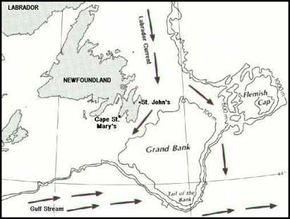
The most easterly part of Newfoundland is the Avalon Peninsula which is connected to the rest of the island by a narrow isthmus. St. John's, the capital city (population 125,000) at 47 37 N 52 45 W is further south than Paris but the climate is predominantly influenced by the Labrador Current which sweeps along the coast carrying Arctic waters south. In recent years the East Coast Trail has been constructed allowing hikers to follow the coast from Cape St. Francis to Cape Race. St. John's Harbour has been sheltering vessels since 1500. St. John's is also well known for it's many musicians and artists including Don Walsh . Sieved.com has very useful information on the restaurants and entertainment in St. John's.
One hundred miles south of Cape Race the Gulf Stream flows north
east to warm northern Europe. The confluence of these two currents creates
fog banks and an abundance of marine life.
You can keep track of the ever changing Newfoundland weather at St. John's and via the Newfoundland Marine Forecast .Environment Canada has weather maps updated every 6 hours which use the global system of weather symbols . Edward J. Hopkins, Ph.D explains a bit more about weather maps. The weather radar in Holyrood displays rain and snow on the Avalon Peninsula.
Each spring the Labrador Current carries southward the pack ice
and icebergs which a few months earlier existed as an unbroken cover in Baffin
Bay and the eastern Canadian Arctic. In summer this
nutrient rich current supports an enormous biomass of plankton which
is at the base of the North West Atlantic food chain including marine mammals
and the major seabird colonies that thrive along the east coast of Newfoundland.
The majority of people living on the island of Newfoundland are
the descendants of people who came from the West Country of England and Ireland.
Newfoundland English is very distinct as you will see from checking out
the Newfoundland
Dictionary
.The biggest wave of immigrants arrived at the beginning of the nineteenth
century. 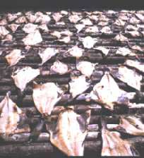 For most of it's history Newfoundland was a colony of England and the
majority of people were engaged in the fishery.From 1500 until the introduction
of the frozen fish industry after 1945, cod was split, salted and sun dried
on wooden flakes. Today this is only done for personal consumption. More
than anything else the fishery has shaped the culture of Newfoundlanders which
has made the closure of the once prolific northern cod fishery in 1992 as
much a cultural as an economic blow.
For most of it's history Newfoundland was a colony of England and the
majority of people were engaged in the fishery.From 1500 until the introduction
of the frozen fish industry after 1945, cod was split, salted and sun dried
on wooden flakes. Today this is only done for personal consumption. More
than anything else the fishery has shaped the culture of Newfoundlanders which
has made the closure of the once prolific northern cod fishery in 1992 as
much a cultural as an economic blow.
The management of the fishery since the declaration of the 200 mile limit in 1977 has been a disaster in the eyes of most Newfoundlanders. Getting much of the blame is the Canadian Department of Fisheries . Between 1977 and 1992 the Department administered the most expensive and inclusive fisheries licensing scheme in human history. Unfortunately scientific advice was ignored by senior bureaucrats and politicians and licences were issued which authorized massive overfishing, mostly by Canadians. An academic perspective on the problems inherent in fisheries management based on the case of the collapse of the Northern Cod stock was done by Bonnie J. McCay and Alan Christopher Finlayson of Rutgers the State University, New Brunswick, New Jersey
Even less loved is the North Atlantic Fisheries Organization( NAFO ) that licences fishing on the Canadian continental shelf outside the 200 mile limit. The modus operandi of NAFO is to allow massive overfishing of a stock under the guise of "research fishing". When the stock has been obliterated it is then declared endangered and fishing is no longer permitted!
Overfishing continues to be studied by scientists notable of whom are Dr. Ransom Myers , Dr. Carl Walters and Dr. Ray Hilborn .
The beginning of modern Newfoundland society can be dated from the arrival of the American military in 1940 to construct a number of large bases. In 1949 Newfoundland became the tenth province of Canada. Since that time there have been vast changes in the traditional fishing society that had endured for centuries as billions of dollars were spent on roads, schools, hydro electric projects, telecommunications and all the infra structure of a modern society. The history of Newfoundland has been preserved at the Newfoundland Museum and at the Newfoundland and Labrador Archives .
John Maunder webmaster and Curator of Natural History at the Newfoundland Museum also has his own very good Newfoundland and Labrador Natural Sciences Website .
Another good source of information is the Encyclopaedia of Newfoundland and Labrador.
One of the unique features of Newfoundland is that there are no
privately owned rivers and lakes and 95% of the total area of the province
is public land open to everyone. Proposals to change this situation have
met with strong public opposition and the flavour of the debate can be seen
on the Newfoundland government website at
Our Smiling Land
Protecting the Legacy
and
Protecting the Legacy Vol 2
.
![]()